


Maricopa County, AZ
Apache
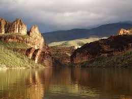
Apache Lake is 45 miles east of Phoenix and is created by the Horse Mesa dam.
Apache Lake is one of four artificial reservoirs created along the Salt River in central Arizona as part of the Salt River Project. The lake is located near the Apache Trail about 65 miles (104 km) northeast of Phoenix. Apache Lake was formed by Horse Mesa Dam which was completed in 1927. The second largest of the four Salt River Project reservoirs (Theodore Roosevelt Lake is the largest), Apache Lake is located about 5 miles (8 km) downstream from Theodore Roosevelt Lake and upstream from Canyon Lake and Saguaro Lake.
The surface area of the lake is 2,568 acres (1,039 ha) at full capacity and it can store 254,138 acre-ft (313,475,000 m3) of water.
Apache Lake is a popular recreation destination within the Tonto National Forest, which is the authority that manages the facilities located at the lake. The lake is located along the Apache Trail and a number of other hiking trails can be found in the area. Many species of fish can be found in the lake, including largemouth, smallmouth and yellow bass, crappie, sunfish, both channel and flathead catfish, walleye and carp.
Swimming – Bass Fishing – Boating – Water Skiing


